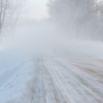
The weather affects every aspect of our lives, far beyond picking up an umbrella on your way out the door. Weather data is critical for industries from ground transportation to aviation to outdoor events, insurance and beyond. We started Tomorrow.io to shake up weather forecasting by zooming in to street-level and providing coverage anywhere that you can find a wireless communication network.
We are excited about bringing a whole new level of precision to weather data in the U.S. and Europe. We won’t have to wait to take it to developing countries, either! Just like African villages bypass expensive cable internet networks with satellite internet, Tomorrow.io technology eschews traditional weather stations, radars, and satellites in favor of a cheaper and more available solution. Satellites provide remote sensing capabilities with near-total coverage but fail to give the accuracy needed by those who rely on the weather to make decisions. On the other hand, smaller sensors can provide very accurate measurements of certain parameters but are localized and costly to maintain.
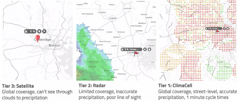
Since weather-sensing technology hasn’t significantly evolved in decades, traditional technology cannot provide both accuracy and full coverage simultaneously.
In the past, only a select group of developed countries had access to the latest measuring tools. Today, Tomorrow.io can help any country get the cheapest yet most precise weather data in the world.
Our software accurately monitors the weather in any location that there is a wireless network. Tomorrow.io is far more accurate than any other dedicated sensor with a 90% correlation between our data and the conditions on the ground. That compares to only 50% for the best radars. Tomorrow.io gets sample data every minute while radars get it only every 5–30 minutes. We can provide a ground resolution of 300 meters (982 feet) in urban areas which beats the 2,000–4,000 meters (6,561–13,123 feet) you’d get with traditional measuring tools. Plus, Tomorrow.io is extremely accurate when measuring the rate of precipitation and classifying it.
Now that we’ve launched our dashboard, the HyperCast™, we can’t stop thinking about the new applications of our sophisticated real-time weather data. Smart cities will calibrate traffic lights and city infrastructure, while retail and e-commerce will refine their understanding of demand. Traditional weather data consumers like airlines and event venues will make better decisions that affect us all. That will make life easier for decision makers across industries and people around the world- come rain or shine.
Zoom in over your street with the Hypercast™ weather software!
Originally published April 2nd, 2017 | by: Shimon Elkabetz, CEO | Tomorrow.io